

Bears Ears National Monument
Bears Ears National Monument, located in San Juan County in southeastern Utah, gets its name from two distinctive twin buttes that resemble the ears of a bear, prominent landmarks in the region. It is celebrated for its stunning natural beauty, rich archaeological resources, and profound spiritual importance to numerous Native American tribes which include the Navajo and Hopi tribes.
The landscape of the park which is made up of approximately 1.36 million acres is incredibly diverse, encompassing winding red rock canyons, forests, and high plateaus. Bears Ears is home to a wide variety of plant and animal life. Wooded areas are made up of juniper, pinyon pine, oak, cottonwood, and sagebrush; while smaller plant life includes columbine, Indian paintbrush, asters, and yarrow. Black bears, mountain lions, bighorn sheep, elk, mule deer, foxes, coyotes, jackrabbits, and squirrels all call Bears Ears home. Flying overhead are eagles, peregrine falcons, California Condors, and owls; and keeping low to the ground are snakes (including rattlesnakes) and lizards.
Planning Our Route
My husband actually suggested I start my recap with, “My stupid husband blindly trusted the heat map on Ride with GPS…” What happened was, yes, he blindly trusted the Ride with GPS heat map when he grabbed a route to modify, but he’s done that time and time again with excellent results. BTW, the heat map shows where other riders have ridden using the past two years of logged riding data which is updated weekly, keeping it as accurate as possible. The darker the red, the more riders have ridden that route.
Jumping ahead, we were in the visitor center two days after the ride when we mentioned that we’d ridden the loop earlier in the week. The guy behind the register said, “Oh, that was you I saw up there? I was in the white truck that passed you on the ridge.” We obviously remembered him because he was the only other human we’d seen on our entire ride. He went on to say that he’d wondered where we’d ridden from because he didn’t see a car up there anywhere. He was quite shocked that we’d “ridden” the fire roads and mentioned that he’s not aware of cyclists riding that route, just people on trail motorcycles. In fact, he’d ridden up there just a few weeks earlier and said even that wasn’t easy. He was either quite impressed with us or thought we were complete idiots.
About the Ride
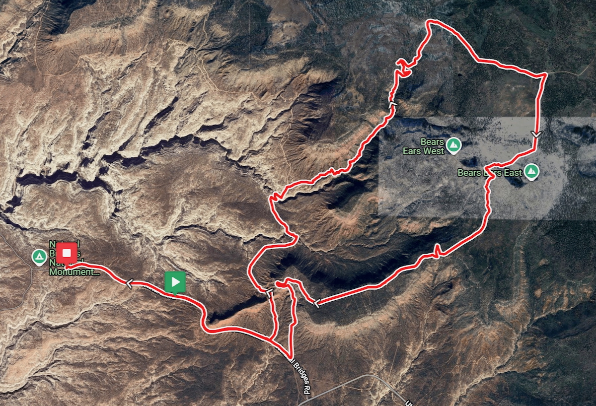
What was expected to be a challenging ride around Bears Ears National Monument was far more difficult than we’d anticipated. After a steady climb on the paved road away from the Natural Bridges National Monument Visitor Center to the Burch Canyon Road turnoff, we were pleased with the road conditions – packed red dirt and gravel. As we rode along, the packed road became scrappier, but ever the optimist, I was sure the conditions would improve just around the next turn. Once we turned onto FR (fire road) 5468 and then 5469, it was clear that we were in for a long haul up to the top of the mountain as we dismounted and hike-a-biked almost exclusively from miles 6.5 to 11.5 which took us 2-½ hours. Our biggest hope was that when we turned onto Wooden Shoe Road and then Elk Mountain Road that the conditions would be greatly improved, and they were.
After a delightful mostly flat ride out the ridge on the dirt packed Woodenshoe Road, we reached Elk Mountain Road and eventually started our descent. The ride down was no walk in the park for me either, and with hairpin turns, 11% grades, and 1,000 foot drop-offs, I was way out of my comfort zone. I spent my descent hugging the canyon wall, and after every other hairpin turn I was on the wrong side of the road, hopeful that there wouldn’t be an oncoming car.
Because I keep my bike Garmin on auto-pause, it kept pausing as I pushed it up the mountain walking slower than the 6 MPH necessary to keep it going. As a result in the Ride Overview stats, I’ve listed my husband’s distance, time, speed, and elevation gain because his Garmin wasn’t pausing and had the more accurate stats.
Those May not be Birds We Hear
My husband and I were both aware that mountain lions sometimes make a high-pitched chirping birdlike sounds. This chirping sound is especially useful for mothers and their cubs to communicate, and when we heard that odd sound we wondered independently to ourselves if there was a mountain lion watching us. At the time, we were pushing our bikes up the fire road in the most remote area of the day – literally in the middle of nowhere with zero cell service. We didn’t mention our suspicion of the sound to each other until after the ride.
Ride Overview
- • Ride Name: 24-BearsEarsBurchCanyontoElkhorn
- • Ride with GPS: Link to turn-by-turn navigation cue sheet
- • Location: Bears Ears National Monument in San Juan County, Utah
- • Start/Finish: Natural Bridges National Monument Visitor Center
- • Course Type: loop with a tail
- • Course Surface: packed dirt, gravel, rocks, boulders, slick rock, and sand
- • Bike: Salsa Warbird
- • Distance: 24.66 miles
- • Time: 3:24:56
- • Average Speed: 7.2 MPH
- • Maximum Speed: 30.9 MPH
- • Elevation Gain: 2,126 feet
- • Elevation Range: 6,509 to 8,432 feet
- • Weather: 65° and sunny, climbing to 82° and partly cloudy
- • Date of Ride: June 23, 2025
- • Start time: 9:11 AM
Fun Pictures Along the Way
All smiles as we rode away from the Natural Bridges National Monument Visitor Center on our way to explore Bears Ears National Monument.

Burch Canyon Road
Just under two miles into our ride we turned onto Burch Canyon Road and were pleased with the road conditions which consisted of packed dirt and small gravel.

After the second climb popped up, my Garmin got confused and didn’t move past this climb. Fortunately, none of the other screens were effected.

Road conditions continued to be good as we descending into the canyon…

A closer butte is blocking a portion of the left of the twin buttes in the distance which resemble the ears of a bear giving the region its name.

Climbing FR 5468 and FR 5469
From the moment we turned onto the first fire road, conditions started to decline. We had to push our bikes many places even where it was relatively flat because of soft sand whipping our rear tires back and forth. I unclipped from my right pedal so I could quickly put my right foot on the ground whenever necessary (with my toe I can flip my pedal from a clipless to a flat for just such situations).

As conditions deteriorated from sand with washouts to larger loose rocks, I unclipped from both sides and rode on the flats for safety reasons.

Occasionally, the road was rideable and at these points we would cautiously get back on our bike for whatever short distance we could manage before we were back to hike-a-biking…


Road conditions took a drastic turn for worse as we started some serious climbing. Washed out gullies and much larger rocks which shifted underfoot made guiding a 20-pound bike up 11% grades extremely difficult as we scrambled to stay upright while slowly making progress up the mountain.
My right pedal kept hitting my left shin and calf as I pushed my bike leaving me with minor cuts, and at some point I scraped my right forearm against a tree branch leaving it bleeding. My husband cut his right calf on a rock and it was at this point that I realized that we’d gotten ourselves into a bad situation. Hearing what could be mountain lions calling each other, knowing that we had limited water with us, and had zero cell service left me a little more than concerned.
We had stopped in the visitor center to let the park ranger know where we were riding and I’d texted our kids to say we were going for a ride in Bears Ears, but other than that our whereabouts were unknown to any other humans. In fact, we didn’t cross paths with anyone else riding or hiking the entire day.


Unbeknownst to us, the worse of the road conditions was behind us when we finally stopped in the shade for a snack. The mountain breeze and the scent of the pine and juniper trees was just what we needed to aid in our rest before continuing on.

Within view of where we’d stopped to rest was a fence with a gate. After maneuvering our bikes through the gate we were back on a slightly sandy, but mostly rideable fire road.


Once we finally summited the mountain, we rested and refueled before continuing on to ride out the mountain ridge.


Woodenshoe Road
After 2-½ hours hike-a-biking up that horrible fire road, we were thrilled with the excellent condition of Woodenshoe Road.


Cattle were free ranging along the road and didn’t seem the least bit bothered by our presence.


A cattle guard separated Woodenshoe Road from Elk Mountain Road where we turned right to ride toward an up close view of Bears Ears.

Elk Mountain Road
At long last we had the perfect view of the two buttes that look like a bear’s ears. This would have been the perfect place to take a pano picture, but I didn’t even think of it. In fact, I failed to get a picture of both ears (buttes) in the same frame. With our bikes lined up, we took pictures down the road with the left of the two ears (Bears Ear East) centered, but with Bears Ears West mostly cut off.


Right ear or Bears Ear West…

Elevation of the two ears…

When it was time to start our descent off the mountain the combination of the steep descent with 1,000 foot drop-offs had me out of my comfort zone once again.


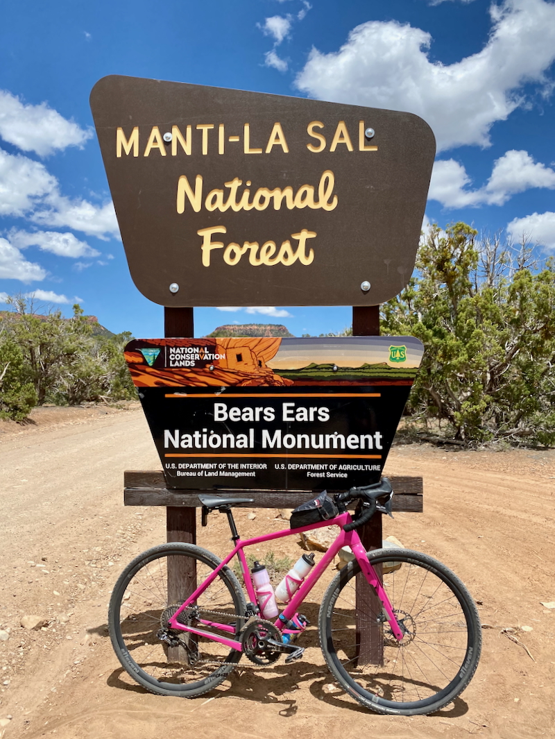
When we left Manti-La Sal National Forest we came upon this sign from behind. We both skidded to a stop knowing we had to get a picture of our bikes propped against it.
We enjoyed a few slightly rolling hills before we started our final descent.


After a much longer ride than we’d anticipated, we were finally leaving the mountain. Four miles later after riding mostly downhill on the paved road, we rolled back into the visitor center parking lot exhausted, mostly unscathed, and with a great story to tell!
Garmin Stats
Post-ride Garmin…

Garmin map and elevation graph…


Final Thoughts on the Rides
I would absolutely not do this ride again on the same route, yet I’m happy we did it now that it’s in the rear view window – it was a character builder. It would have been much better if we had done it in the reverse direction as an out-and-back, turning at the end of the ridge at the fire road. However, not realizing the terrible condition of the fire road before setting out on our ride, we didn’t know to do that.
The scenery was stunning, the weather was quite good, and I was in good company, but this was a one and done ride. Even if we’re back in Bears Ears National Monument, I will not be looking to redeem myself.
Questions
- • Have you visited Utah? ~ Many times and I lived there from 1981 through 1983.
- • Had you heard that mountain lions sometimes make birdlike chirping sounds? ~ yes
- • Do you stop and relax occasionally to fuel or take pictures, or barrel on through when on a long run or ride? ~ pictures, always pictures, unless I’m racing
A character builder indeed! Wow, Debbie, what an adventure! ♀️
The photos are gorgeous, but your description of that hike-a-bike section had me sweating just reading it. Two and a half hours of pushing bikes up fire roads with sand, loose rocks, and washed-out gullies takes some serious grit (and maybe just a little bit of madness). I can’t believe you also had to factor in mysterious birdlike mountain lion sounds – talk about unsettling when you’re already in the middle of nowhere with no service.
Yes, this would be a one and done for me too. Having said that, sometimes the most miserable-in-the-moment rides turn into the best stories afterward!
Thanks, Catrina, it certainly was one for the books! And I bet you’re not surprised that my husband and I have told that story to our various cycling friends more than once. 😉
PICTURES!
I know that wild animals make all kinds of sounds to lower your inhibitions and attract you. Women screaming, babies crying, birds chirping… all of it. And I would fall for it every single time.
What an incredible adventure. I’ve never been to Utah, but obviously, it’s on the list.
This ride was definitely THE event of our entire 4-week road trip, not that we’d planned it that way. It’s certainly the one we’ve talked about the most.
Dag Deb, what an adventure!
Reading your summary, I envisioned you guys eating wild berries and mushrooms for fuel.
Then drinking from a stream with a Lifestraw.
CJJR
You’re right, Chuck, what an adventure; and you can be assured that next time we see you we’ll be telling you all about it once again! 😉
Bill said to tell you that if we’d tried to drink from a stream with a Lifestraw, we would have been sucking sand. There wasn’t any water in sight!